Playing cards
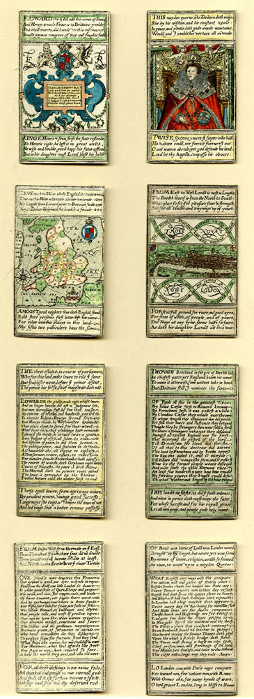 Among the most intriguing and
attractive of all printed images from 17th-century Britain are packs of pictorial playing
cards, through which complex data could be presented in an appealing yet flexible way. The
earliest series is a set of cards showing the maps of the counties of England, which dates
from c. 1590, and a further interesting series of cards which combine maps with other
mnemonic devices dates from c. 1605. Mostly, however, it was in the last decades of the
century that such cards enjoyed a vogue. Many of these comprise sets of images of the
political crises of the day, which are presented almost as strip cartoons, from the
‘Knaveries of the Rump’ to the Popish Plot and the Glorious Revolution. Others are didactic
or recreational, ranging from sets of maps of the countries of the world and other
educational tools to fortune-telling cards. A few such sets already appear on our database,
but this is an area which we hope to develop at a future date.
Among the most intriguing and
attractive of all printed images from 17th-century Britain are packs of pictorial playing
cards, through which complex data could be presented in an appealing yet flexible way. The
earliest series is a set of cards showing the maps of the counties of England, which dates
from c. 1590, and a further interesting series of cards which combine maps with other
mnemonic devices dates from c. 1605. Mostly, however, it was in the last decades of the
century that such cards enjoyed a vogue. Many of these comprise sets of images of the
political crises of the day, which are presented almost as strip cartoons, from the
‘Knaveries of the Rump’ to the Popish Plot and the Glorious Revolution. Others are didactic
or recreational, ranging from sets of maps of the countries of the world and other
educational tools to fortune-telling cards. A few such sets already appear on our database,
but this is an area which we hope to develop at a future date.